As we prepare to leave the first full month of 2021 in the rear view mirror, winter sports enthusiasts will likely look at the weekend forecast with a bit of excitement in Southwest Michigan, while on the other side of the state line they may be bracing for more of a winter driving hassle than a romp in the snow. The happiest crowd will likely reside among the snow plow jockeys for hire hoping for business.
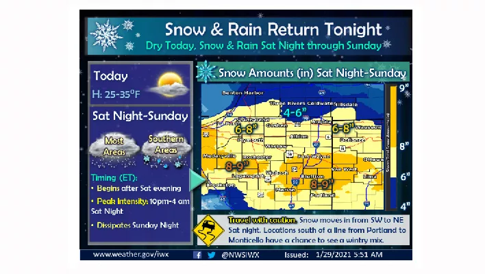
The National Weather Service in Northwest Indiana has issued a Winter Storm Watch for portions of Northern Indiana with forecasts on Saturday and Sunday of anywhere from 6 to 9 inches of snow. On this side of the border, in Southwest Michigan, the forecast drops to the potential for 4 to 6 inches of snow, but no formal watch or warning at this time.
The National Weather Service reports, “Cold and dry weather today into Saturday will yield to a snowy weekend with accumulating snow across the entire area. Snow will overspread the region Saturday evening and become heavy at times Saturday night into Sunday morning. Travel will be impacted by early Sunday.”
The official NWS forecast for St. Joseph & Benton Harbor looks like this as of this morning:
- Saturday: A 20 percent chance of snow after 4pm. Mostly cloudy, with a high near 32. Southeast wind 15 to 20 mph, with gusts as high as 25 mph.
- Saturday Night: Snow, mainly after 7pm. Low around 27. East wind around 20 mph, with gusts as high as 35 mph. Chance of precipitation is 100-percent. New snow accumulation of 3 to 7 inches possible.
- Sunday: Snow. High near 32. Northeast wind around 20 mph, with gusts as high as 30 mph. Chance of precipitation is 80-percent. New snow accumulation of less than one inch possible.
- Sunday Night: A 40-percent chance of snow before 1am. Cloudy, with a low around 25.
The forecast graphic accompanying this story on Moody on the Market is courtesy of the National Weather Service Northern Indiana office.