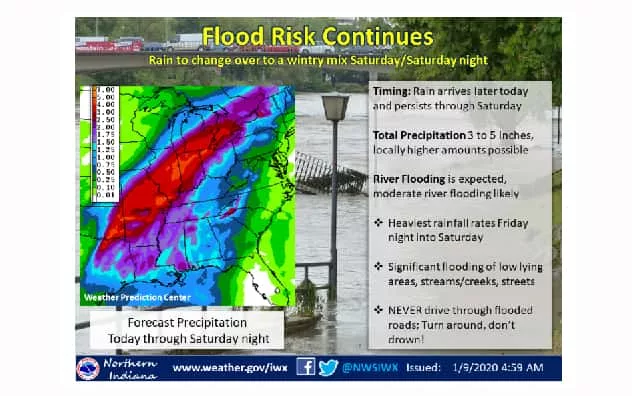
Get ready to batten down the hatches and maybe even reach for the sandbags as the National Weather Service is warning of flood risks in the days ahead. Flood Warnings have been issued for several stretches of the St. Joseph River at Elkhart, South Bend and Niles thus far.
The National Weather Service office in Northern Indiana says a complex, major winter storm will provide a period of exceptionally wet weather across the region, as rain develops tonight in an initial frontal wave as it ejects from Kansas into the Upper Midwest.
The heaviest rainfall rates will occur tomorrow night, Friday, January 10th into Saturday the 11th, as another frontal wave tracks from Texas into northern Indiana. Widespread, extreme rainfall amounts will most likely lead to flooding issues this weekend and into next week.
Temperatures will be noticeably warmer today and tomorrow, with highs reaching into the 40s today and into the upper 40s to middle 50s on Friday. Colder air begins to infiltrate Saturday and Saturday night, which may lead to freezing rain, mixed at times with snow and/or sleet.
However, with regards to the wintry mix late this weekend, confidence is low. Amounts of ice and snow, as well as the area of greatest impact remains uncertain at the moment.
Meanwhile, the Flood Warnings are as follows:
Niles: The St. Joseph River at Niles is on Flood Warning from Sunday evening until further notice. At 1 pm today, Thursday, 1/9/20, the stage was 7.6 feet and steady. Minor flooding is forecast. Flood stage is 11.0 feet. The forecast is for the river to rise above flood stage Sunday evening and crest near 13.8 feet around 1 am on Wednesday, January 15th. At 14.0 feet, moderate flooding occurs in Niles. High water will affect Water Street, and low sections of Marmont and River Streets in Niles. Low-land flooding surrounding Island Park and low lying areas along the river near the wastewater treatment plant can be expected.
Elkhart: The St. Joseph River at Elkhart is on Flood Warning from Sunday evening until further notice. At 1pm today, Thursday, 1/9/20, the stage was 20.7 feet and steady. Moderate flooding is forecast with flood stage at 24.0 feet. The river will rise above flood stage Sunday evening at Elkhart and crest near 26.0 feet around 7pm on Tuesday, January 14th. At 27.0 feet, water begins to affect businesses on East Jackson Street. Flooding affects a few first floor residences in the South Shore Drive area across from the hospital. This crest compares to a previous crest of 26.1 feet which occurred on March 12, 2009.
South Bend: The St. Joseph River at South Bend is on Flood Warning from Sunday morning until further notice. At 4 am yesterday, Wednesday, January 8th, the stage was 2.9 feet and unknown. Moderate flooding is forecast. Flood stage is 5.5 feet. The forecast is for the river to rise above flood stage Sunday morning and crest near 8.8 feet around 1 am next Wednesday, January 15th. At 9.0 feet, major flooding is in progress. Flooding almost completely submerges parks and floods local streets near the St. Joseph River. This crest compares to a previous crest of 9.0 feet which occurred on Mar 12, 2009.
Authorities remind everyone to avoid driving into flooded roadways. Turn around to avoid catastrophe.


